


ROSSFORD F Voting District, Wood County, Ohio
About
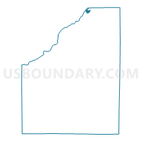
Outline

Summary
| Unique Area Identifier | 653397 |
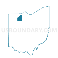
| Name | ROSSFORD F Voting District |
| County | Wood County |
| State | Ohio |
| Area (square miles) | 0.49 |
| Land Area (square miles) | 0.49 |
| Water Area (square miles) | 0.00 |
| % of Land Area | 100.00 |
| % of Water Area | 0.00 |
| Latitude of the Internal Point | 41.60535160 |
| Longtitude of the Internal Point | -83.56814880 |
Maps

Graphs
Select a template below for downloading or customizing gragh for ROSSFORD F Voting District, Wood County, Ohio


Neighbors
Neighoring Voting District (by Name) Neighboring Voting District on the Map
- PERRYSBURG TWP HAMLET Voting District, Wood County, OH
- ROSSFORD A Voting District, Wood County, OH
- ROSSFORD D Voting District, Wood County, OH
- ROSSFORD H Voting District, Wood County, OH
- ROSSFORD I Voting District, Wood County, OH